Since 1985, the Senckenberg Research Institute, Division of Botany and Molecular Evolution, has been mapping biotope types throughout the entire city area – excluding some larger industrial facilities – on behalf of the city council of Frankfurt/Main.
The connection of the biodiversity mapping to the Senckenberg Research Institute is obvious, as one focus of Senckenberg’s research traditionally lies in the Rhine-Main area and regional flora and fauna have been documented in the collections for more than 200 years. This provides excellent prerequisites for recording, assessing and documenting changes in flora and fauna. In cooperation with the “Hessische Landesanstalt für Umwelt” and the City of Frankfurt am Main, the 10th meeting of the working group “Biodiversity mapping in urban areas” was held at the Senckenberg Research Institute in 1988, the results of which were published in the “Courier Forschungsinstitut Senckenberg”, vol. 126.
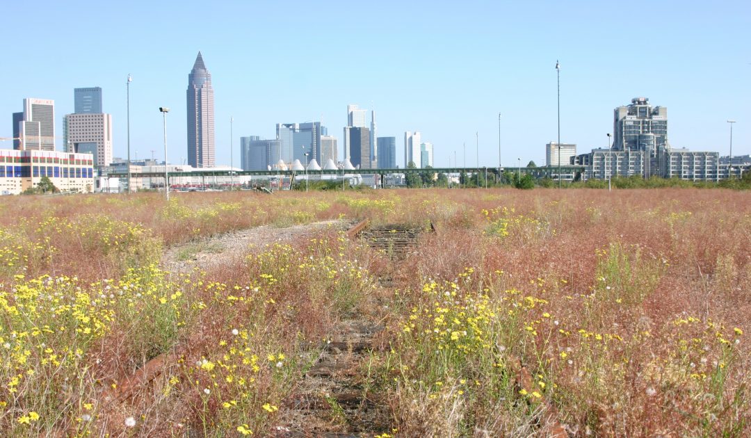
In 1990, the first round of biodiversity mapping of the urban area was completed, and since then revisional mapping has been carried out every six years. Since the year 2000, biodiversity mapping has also taken place in the Frankfurt city forest, which was previously excluded from the investigations. Since foundation of the working group in 1985, more detailed floristic-faunistic studies have been carried out in selected areas and habitats of the city of Frankfurt in the form of so-called “precision mappings”, which provide answers to issues such as landscape-structural features and connectivity, species inventory, nature conservation as well as maintenance and development and have led to more comprehensive special projects (e. g. “Frankfurt 21”; “Stadtwald”; “Flughafen-Projekt”, “Frankfurter Kreuz”). The results of this work form an indispensable basis for the city’s sectoral planning (landscape and nature conservation planning, species and biotope protection programmes, intervention mitigation regulations). In addition to providing scientifically sound information on the condition, endangerment and need for protection as well as the development capacity of nature in the city, they also provide information on the distribution of habitats, plant and animal species and enable statements to be made on their potential for endangerment and on the planning of protective measures.
Biodiversity mapping of the city of Frankfurt since 1985
1st mapping 1985-1990
2nd mapping 1993-1997
3rd mapping 1998-2003
4th mapping 2005-2012
5th mapping 2013-2017
6th mapping 2018-
Major topics of the 4th monitoring period (2001-2005) are:
Realization of 3rd revisional monitoring using the key to habitat types (“Biotoptypenschlüssel”)
Realization of biotope mapping in the “Stadtwald“, the municipal forest south of Frankfurt/Main
Registration of the habitats to be protected according to § 23 HENatG (Hessisches Naturschutzgesetz) and habitats according to fauna-flora-habitat (FFH) directive
Exploration of species diversity and dynamics of selected biotope types
Evaluation of accompanying measures towards renaturation, maintenance, and development (e. g. Nidda rivulet, former airbase Bonames)
Since 2009, the working group has been running the website about flora of Frankfurt, where a lot of information on the local plant life can be found and where citizens can report plant finds.
Since 2016, the working group Biodiversity mapping has been carrying out ecological monitoring on the Frankfurt sites of the joint project “Cities dare wilderness – experience diversity”. For this purpose, studies on fauna, flora and habitats are carried out year-round at the Bonames North Park and at the Monte Scherbelino. More information.
With your donation, you help the Senckenberg Society to conduct natural scientific research and make our results accessible to the public through publications, exhibitions, educational projects, and many other initiatives.